This first briefing of the year 2013 for representatives from EU and others was held to point out the elements dictating the future of the peace process between Israel and Palestine.
The given presentation was prepared as part of the project entitled “Monitoring the Israeli activities in the Occupied Palestinian Territory and assessing their impacts on the viability of a future Palestinian statehood”, which is financially supported by the EU and SDC.
It provides a narrative, statistical and cartographic description of the current status of the settlement activities in the OPT.
The following summary briefly outlines the core statements of the presentation.
Elements Dictating the Future of the Peace Process
This first briefing of the year 2013 for representatives from EU and others was held to point out the elements dictating the future of the peace process between Israel and Palestine.
The given presentation was prepared as part of the project entitled “Monitoring the Israeli activities in the Occupied Palestinian Territory and assessing their impacts on the viability of a future Palestinian statehood”, which is financially supported by the EU and SDC. It provides a narrative, statistical and cartographic description of the current status of the settlement activities in the OPT.
The following summary briefly outlines the core statements of the presentation.
To begin with, an overview of the conflict between the Israelis and the Palestinians from 1948 through the present day demonstrated the fragmentation of Palestinian land and communities into disconnected cantons combined with frequent collective punishment closures, house demolitions, withdrawal of identify cards and the confiscation of private property. Although since 1967 the United Nations Security Council Resolution 242 emphasized the inadmissibility of the acquisition of territory by war and the need to work for a just and lasting peace in which every State in the area can live in security and called for the withdrawal of Israeli armed forces from territories occupied in the recent conflict and achieving a just settlement of the refugee problem, the conflict has been going on for sixty five years. Yet after so many years that peace is fading, it was pointed out that there are recent attempts to resurrect the peace process.
Where did we go?
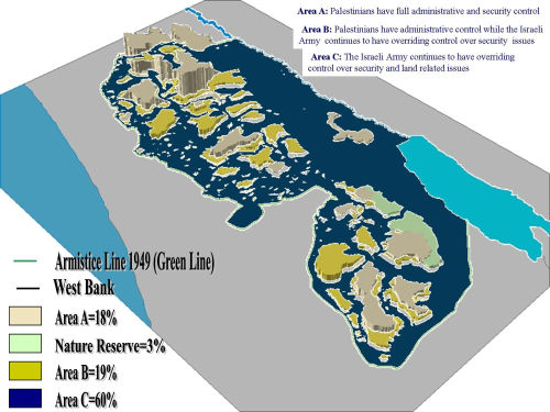
Since the signing of the Egypt-Israel peace treaty (1979), various initiatives were put forth by Israel and others to further the peace process in the Middle East. These efforts eventually led to the convening of the Madrid Peace Conference (October 1991), held under American and Soviet auspices, which brought together representatives of Israel, Syria, Lebanon, Jordan, and the Palestinians. The formal proceedings were followed by bilateral negotiations between the parties and by multilateral talks addressing regional concerns. Following intensive behind-the-scenes contacts in Oslo between negotiators for Israel and the Palestinian Liberation Organization (PLO), general principles were formulated outlining self-government arrangements of the Palestinians in the West Bank and the Gaza Strip. Its signing, on September 13th in 1993, was preceded by an exchange of letters between PLO Chairman Yasser Arafat and Prime Minister Yitzhak Rabin, in which the PLO renounced the terrorism, pledged to invalidate those articles in its covenant which deny Israel's right to exist, and committed itself to a peaceful resolution of the decades-long conflict. In response, Israel recognized the PLO as the representative of the Palestinian people. Under the Interim Agreement, the West Bank was divided into three types of areas: A, B, and C. the Israeli military withdrew from lands classified as area A, and complete autonomy over administrative and security issues was assumed by the Palestinian Authority. Area A, according to the Oslo II agreement, covered the main cities of the West Bank, except for Hebron which had a special agreement. In areas B, the Palestinians have full control over civil affairs while Israel continues to have overriding responsibility for security. These areas comprise most of the Palestinian towns and villages. Areas C, covering almost 61% of the West Bank, are under Israeli control. In this area, the Palestinian Authority has no control what so ever and the area remains under absolute and full control over land, security, people, and natural resources. The majority of Palestinian agricultural land lies in these territories, which points out the significant importance of the area.
Area (A, B, C) distribution and classification
As listed below in Table 1, in particular 87% of the nature reserve, 90.1% of the forest, 48% of the wells, 37% of the springs and 49,1% of the roads are located in area C. These numbers make it very clear, that without any access to those resources it is very unlikely that Palestine will reach the goal of becoming a sustainable state.
Table 1: Significance of Area C
|
Type
|
Area A
Dunum
|
Area B
Dunum
|
Area C
Dunum
|
Total
|
Area C
Percentage
|
|
Nature Reserve
|
52,300
|
42,600
|
607,730
|
702,630
|
87
|
|
Forest
|
7,000
|
9,000
|
59016
|
65016
|
90.1
|
|
Wells
|
223
|
87
|
287
|
597
|
48
|
|
Springs
|
70
|
122
|
112
|
304
|
37
|
|
Roads
|
2900 km
|
3100 km
|
5800 km
|
11800 km
|
49.1
|
According to Oslo it was agreed that the West Bank and Gaza strip territory, except for issues that will be negotiated in the permanent status negotiations, will come under jurisdiction of the Palestinian council in a phased manner to be completed within 18 months from the inauguration of the council. Furthermore Palestinians expected Israeli withdrawal from 95% of the West Bank by November 1997.
Nevertheless the present reality in Palestine reflects a geographical discontinuity which implies the systematic segregation of Palestinians into isolated enclaves and separation from vital resources by the presence of settlements, bypass roads, the Segregation Wall, and closed military zones. Instead of relaxing the restrictions in the occupied territories (OPT), the policy of internal closure have increased, while access to the Gaza Strip has been further restricted as a result of declining security in the region. In spite of these facts the core problem lies in the ongoing, unrestricted construction of settlements in the West Bank. An analysis of Satellite images shows a total number of 196 Israeli settlements in addition to 232 outposts in the West Bank (including those in East Jerusalem). All together there are close to 700,000 Israelis living in the West Bank (including East Jerusalem). These concerning developments seriously question the Palestinian approach of “Trading Peace for Justice”. It is worth mentioning that the numbers of settlers vary depending on the source. In this presentation the relatively high level of the Israeli population stirs from the fact that many Yeshiva students live in the settlements for one and a half years to replace the military service and often remain in the area even after their studies. Not taking into account the latter, hence many statistics derive from the numbers mentioned above.
On April 30th in 2003, “Roadmap for Peace” finally called on Israel “to freeze all settlement activities”,including natural growth. But despite international criticism of the Israeli planning and building policies over the years in Israeli settlements, including East Jerusalem, Israel continues in a defiant manner to expand the settlements although they stand to be the foremost obstacle to achieve any real progress in the peace process.
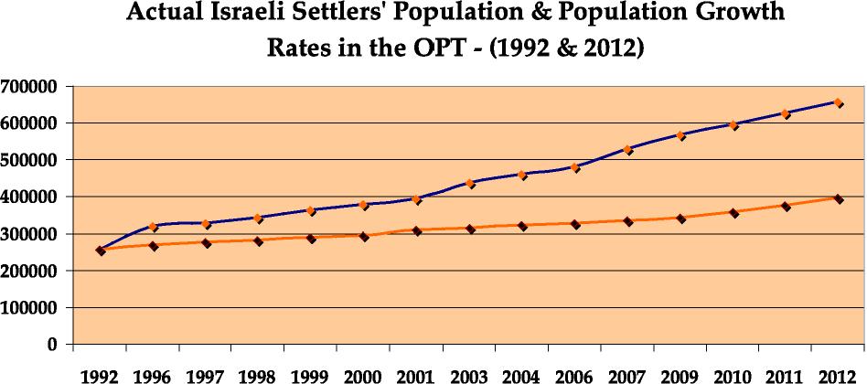
The average natural growth of Israeli settlements can be estimated at 5.8%. As a matter of fact the increasing number of settlers has nothing to do with the actual growth of the settlement's population in recent years – a rate of growth which, because of immigration from outside of the settlement, is actually much higher than the so-called "natural growth" rate of the settlement which is only 1.7%
(e.g., growth due to births, etc.). Following this percentage the rate of Israeli settlers in the West Bank would not exceed 300,000.
Figure 1: Israeli Settler´s Population and Population Growth Rates in the OPT (1992-2012)
In this regard there is reason to believe that the exaggerated housing prices inside Israel are willingly implied to incite the population to move to cheaper settlements in the occupied territories. Furthermore the given benefits such as luxurious houses and tax reduction further encourage the assumption.
The unwillingness of the Israeli government to address this problem can be seen as part of an overall strategy which is characterized by creating facts on the ground, the continue of settlement expansion, filling the gaps to create territorial contiguity between settlements in the form of blocks, unleashing the settlers and giving them the green light to build at will roads to protect Israeli declared as state land, encouraging investments in settlements through tax exemption and classifying settlements as priority development areas, bypassing legal Tabu registration to encourage fraud and denying Palestinians the right to appeal land expropriation and finally by legitimizing outposts and integrating others with nearby settlements.
In a letter from George W. Bush to Prime Minister Ariel Sharon on April 14th in 2004, the US President expresses that he encourages the “(…) establishment of a Palestinian state that is viable, contiguous, sovereign, and independent, so that the Palestinian people can build their own future in accordance with my vision set forth in June 2002 and with the path set forth in the Roadmap”. This statement however does not reflect the realities on the ground which demonstrates the construction of 16125 new housing units in the occupied West Bank, only between November 2012 and May 2013. Considering the natural birth rate of 1.7%, this growth rate shows an unnatural expansion, six and a half times higher than the actual needs.
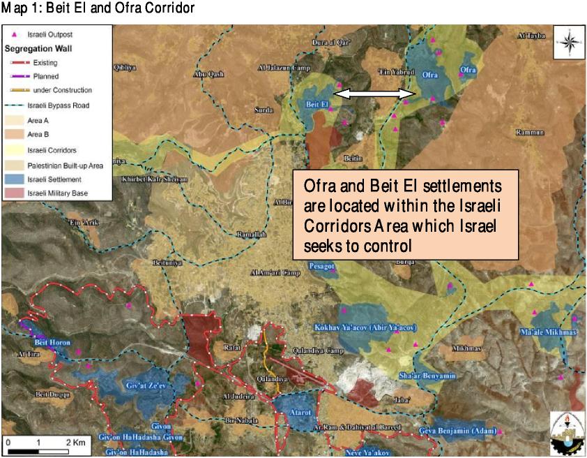
An example of Israel’s exaggerated housing construction can be found in Of ra and Beit El. Both settlements are located within the Israeli corridors area which Israel seeks to control. On May 8th in 2013 the Israeli Minister of Defense approves the construction of 296 housing units, out of 500 designated for Beit El, for settlers from Ulpana outposts. In addition the plan of constructing 250 housing units in Ofra settlement, approved in January 2013 by the Israeli Minister of Defense, indicates a similar case. Former Israeli Prime Minister Ehud Barak stated, that Ofra nad Beit El will be annexed to Israel under any final status agreement. Hence the extension of these settlements will cement the final linkage of both areas (see Map 1).

 Also following the latest settlement developments in Zanuta area and the 8 communities east, all together located in the southern Hebron Hills (see Map 2), indicate a further increase of Palestinian land expropriation. The inhabitants in Zanuta were told evacuate the village under the pretext that it is built on an archaeological site, as well as the other 8 communities, which are allegedly located in an Israeli military training zone. The threat of eviction to the 8 communities and the demolition of Zanuta village arise tremendous doubts of Israel’s intention of resetting the Segregation Wall route to the 2004 plan at the targeted location.
Map 2: Zanuta village and 8 communities under threat of eviction and demolition
Given the actual number of already approved housing units in the West Bank there is reason to believe that Israel does pursue the interest in finding a just solution for the Palestinians but indicate a systematic cleansing of the Arab population of the area.
As discussed in the presentation the following chapter evaluates in particular two target areas of the Israeli occupation, such as the Jordan Valley and Jerusalem.
The Jordan Valley within the Israeli claws of occupation
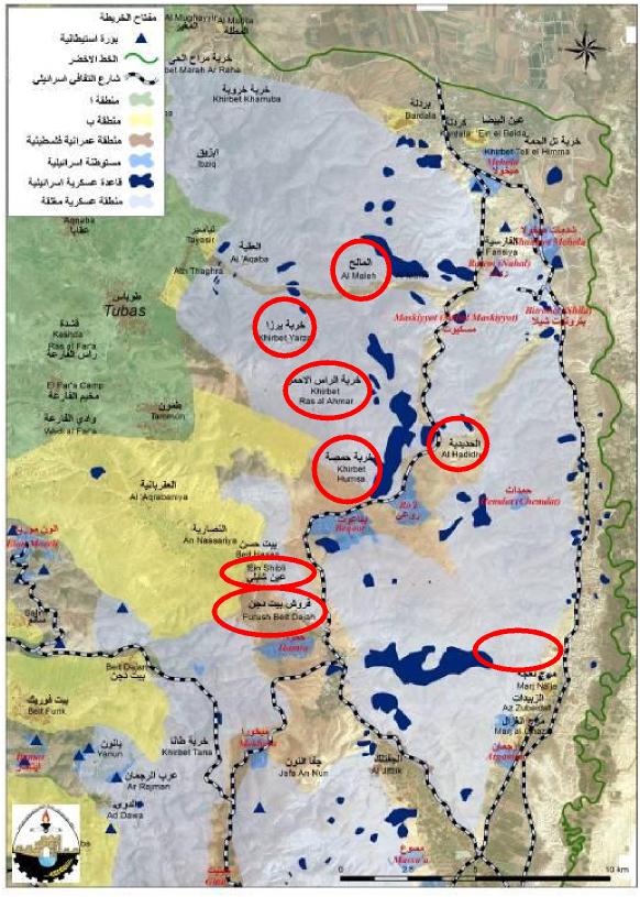
Palestinian residents of the Jordan Valley are mainly farmers or Bedouin’s, mostly living in enclaves hemmed in by closed Israeli military zones, checkpoints and more than 30 Israeli settlements. Their movement is severely hindered by a stringent permit system and by "live f ire" zones. Here, the Israeli military sometimes carries out training exercises in close proximity to Palestinian communities – and even inside population centres and villages.
In order to create a buffer area between Israel and its neighbours, Kherbit Yarza is one among many communities targeted with demolition & evacuation in the Jordan Valley area by the Israeli Occupation Authorities. Furthermore the Israeli Civil Administration handed out, citizens of Al Mayta , Al Hammamat and Al Burj in Wadi Al Maleh area in the Jordan Valley, 12 military orders to stop the construction at residential facilities, tents and animal sheds.
Map 3: Targeted Areas of eviction orders and demolition
 /span>
An overview of the military orders issued for destruction during the last months gives the following list:
a) November 2012: Israeli orders to evacuate 48 Palestinian families
b) January 2013: Israeli orders to evacuate 56 Palestinian families and demolition of 72 structures
c) February 2013: Israeli orders to evacuate 38 Palestinian families and demolition orders targeting 25 structures
d) March 2013: Israeli orders to evacuate 34 Palestinian families
e) April 2013: Israeli orders to evacuate 79 Palestinian families and the demolition of 6 structures
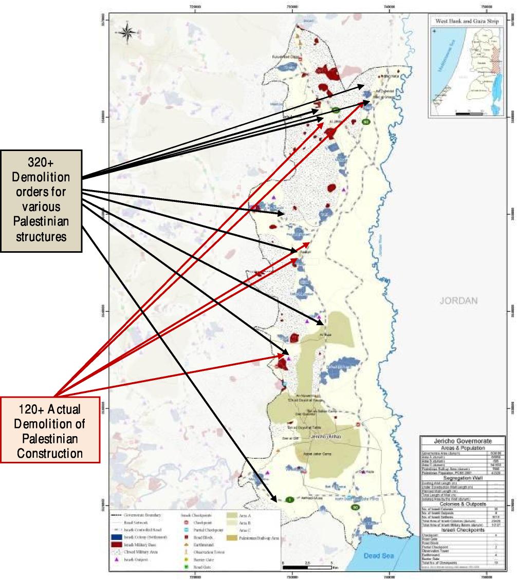
As demonstrated in Map 3, in conclusion there have been more than
320 demolition orders for various Palestinian structures and more than 120 actual demolitions of Palestinian construction during the last year.
Map 4: Overview of Demolition orders
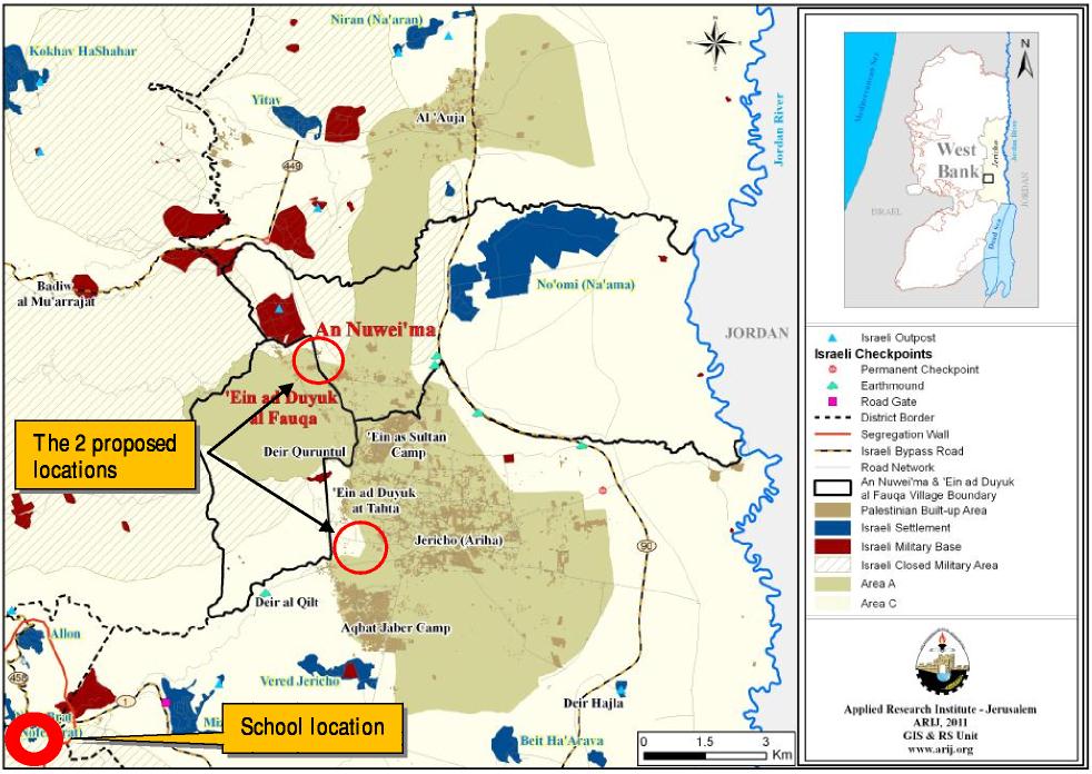
The latest demolition orders disclose that only recently the Israeli Civil Administration (ICA) notified Al Khan Al Ahmar elementary school of its intention to relocate the school to two
locations, the first to the north of An Nuwei’ma village, and the second to the south of Ein Ad Duyuk At Tahta. If the ICA implements its decision, 85 students will have to travel 22 km to reach the nearest School in Jericho.
Map 5: Al Khan Al Ahmar Elementary School Relocation
Jerusalem
Israeli construction work in the West Bank has been gradual increasing since it first started. Only in the last 6 years there has been a progressive growth in the number of settlements. In the case of Jerusalem this development is reflected by the fact that Palestinian land is being confiscated under the pretext of greening the city.
For this purpose on March 5th in 2011, the Regional Planning Committee decided to deposit Plan 11092A for public review. This plan would establish a National Park on the eastern slopes of Mount Scopus, beyond the Green Line, in a wadi nestled between the Palestinian neighborhoods of Isawiyya and Al Tur. Under routine circumstances, the declaration of a national park would not necessarily generate interest. But the circumstances of this plan and its ramifications can hardly be
considered as routine.
Israel has already expropriated more than 35% of the privately owned land of East Jerusalem for the purpose of building settlement neighborhoods (in excess of 50,000 residential units for Israelis). Now, additional lands owned by the residents of Issawiya and A Tur will be, to all intents, expropriated by Israel. While declaring the site a national park does not nullify the owners’ property rights, it inevitably deprives them of the ability to exercise these rights in any meaningful way by denying them the ability to develop or sell their land. The declaration of the park will, in effect empty ownership of virtually all practical significance.
The goal of Plan11092A is self-evident: To be a link between the two concentric encirclements of Palestinian East Jerusalem: the inner encirclement of the Old City and its visual basin, as designated by the governmental Old City Basin Project, and the outer encirclement in Greater Jerusalem, as disclosed by the E-1 plan between Ma'ale Adumim and East Jerusalem. The new national park will be a bridge, creating forging a geographical link between the Old City basin and E-1.
Similarly to the latter case the Jerusalem Municipality has approved a contract to carry out waste treatment at a site in the Atarot Industrial Zone, in East Jerusalem. Ironically the contract was justified on the basis of the need to rectify the illegality of depositing waste beyond the Green Line – something the proposed to accomplish, in part by establishing a new waste treatment installation that is also beyond the Green Line. Plan 3900 designates a 500 dunum area in East Jerusalem, consisting of the slopes below Ras Khamis, the Shuaf at Refugee Camp and Anata, immediately to the north of the French Hill/Maale Adumim Road- as a waste treatment facility. Once implemented, the dumping side will leave no space for Sh´afat Camp, A´nata and Isawiyya to expand. Furthermore the plan will require the displacement of approximately 120 Bedouin residents. Moreover the proposed site dovetails, physically, with the E-1 Plan and the Mount Scopus Slopes National Park Scheme. The cumulative impact of these schemes is the creation of a coherent, contiguous physical link between Maale Adumim and Jerusalem, and the isolation of the Palestinian populated areas nearby.
Map 6: National Park 11092A and Dumping Side 13900
A third case of recent settlement activities presents Plan 10188. The parcel in question is located north of the UN headquarters and regularly used by the Elad settler organization for tours and sports activities. Under a contract between Elad and the Jewish National Fund (JNF), the settler organization is permitted to rent a building on the land. During the past several years, Elad illegally fenced off an area and added trailers serving as offices, storage spaces and group lecture rooms. The JNF is now advancing the plan in order to legalize the fence and trailers by designating the Elad controlled area as a tourism center. Ya'ar Hashalom is one of a chain of national parks designed to solidify Israeli control over the Old City Basin.
In conclusion the natural growth of the surrounding villages outside the old city will become a problem in the future due to the lack of living space. They will become entirely closed in by both, the expanding settlements and the Israeli West Bank Barrier, placing severe constraints on the movement of residents and their access to services outside the villages.
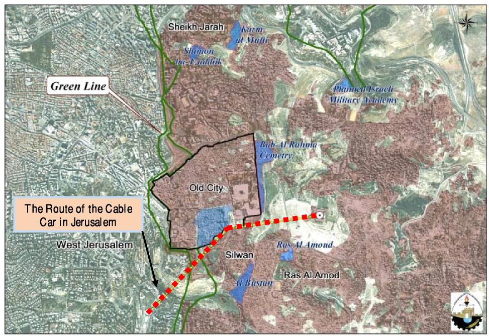
At the same time Israel is not only trying to fortify it´s settlements outside the old city but also
inside. Hence another attempt to de-characterize Jerusalem and force ethnic identity on it, is the planned construction of a two-subdivision cable-car system that will transport tourists and visitors (an average of 6000 an hour) to and from the Western Wall. As demonstrated in Map 6, one line will connect Dung Gate (the Old City gate closest to the Western Wall) with the Mount of Olives to the east. A second line will connect Dung Gate with the Khan Theater on Hinnom Ridge to the west. The cable car is set to operate in 2015 and is a joint project between the Israeli Municipality of Jerusalem, Jerusalem Development Authority and the Ministry of Transportation and will extend a length of more than 1030 meters. By creeping and swallowing the Palestinian communities in east Jerusalem the fronts will blur and the division between east and west is going to vanish. As a final result it will be impossible to make east Jerusalem the capital of Palestine.
Map 6: Cable Car Jerusalem
Away from Jerusalem city and Jerusalem area there are other significant expansions of settlement activities which are worth to be mentioned.
Thus according to the Israeli M inistry of Housing and the Israeli Land Administration there were allocated some 660 pieces of Land to expand settlements in Pisgat Ze’ev and Ma’ale Adumim. At
this state it is not clear yet what kind of claims the Israeli settlers are submitting, regarding the land ownership and expansion of these settlements. With this lack of transparency the registry is able to bypass regular Tabu land-listing processes, which appears to be designed to prevent Palestinians from appealing the validity of the ownership listings. The registry process is supported by deputy attorney general Mike Blass, along with Defense Ministry legal adviser Ahaz Ben-Ari, Civil Administration head Brig. Gen. Moti Almoz and Defense Ministry settlement adviser Eitan Broshi. Additionally the Israeli Local committee recommended approving a plan to build a military college on the Mount of Olives in east of Jerusalem city. The plan will reportedly cover 42,000 square meters on lands. Moreover on May 5th in 2013 Israeli settlers raided Ush Ghurab, east of Beit Sahour, in an attempt to establish an outpost after acquiring permission from the Israeli Army to recondition the former Army structures to residential houses.
Which consequences the increased settlement activities have for the Palestinians, shall be explained in the following chapter. In this regard the resume focuses especially on house demolitions in Bethlehem area.
Construction in the Israeli Settlements
In June 2002, Israel began implementing a unilateral separation plan in the West Bank, in which it started issuing military orders to seize Palestinian lands under the pretext of security and started constructing the Segregation Wall. The Israeli Segregation Wall cuts off many Palestinian communities and villages from neighboring towns and cities. Individuals living in segregation zones, or newly created ethnic Palestinian ghettos, are separated from friends and relatives living in nearby villages. Residents of the ghettos are required to obtain permits from the Israeli Occupation Authorities simply to access their homes. Non-residents are restricted from entering these areas. Additional Palestinian communities have been isolated from their agricultural lands which lie on the opposite side of the wall. As a result the construction of the Segregation Wall significantly impairs the ability of many Palestinian families to earn their living.
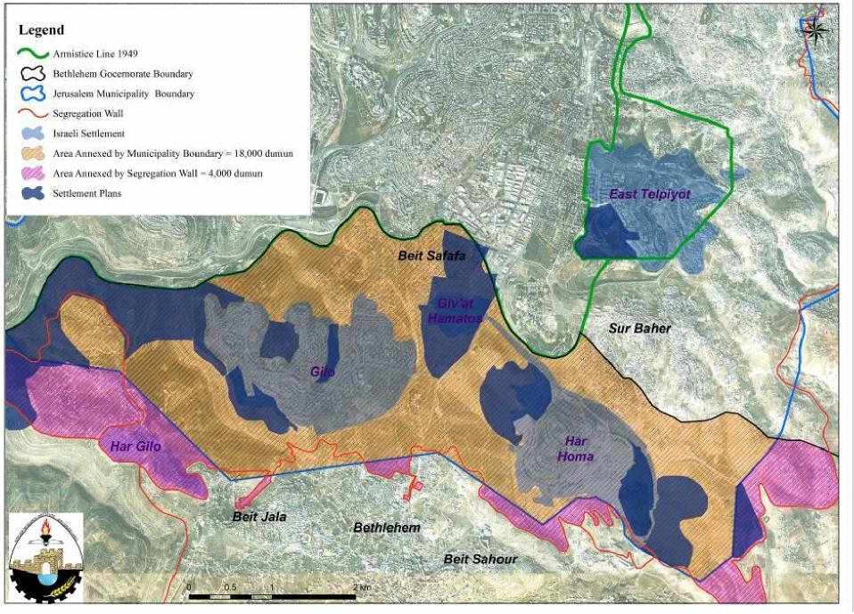
For example, in the Bethlehem District alone, 5 villages will be isolated west of the Segregation Wall while another three will be enclosed by the wall and sealed into enclaves. In respect thereof 18000 dunums have been taken from Bethlehem area, including Gilo, Beit Safaf a, Har Homa and Giv´at Hamatos which represent the total size of Bethlehem, Beit Jala and Beit Sahour together.
These villages, and others like them, comprise newly created ethnic Palestinian ghettos, surrounded by the Wall, and facing isolation and extremely difficult economic and social conditions. After building the Segregation Wall, an additional 4000 dunums where annexed as Israeli state land. As indicated by Map 7, for the first time in history, Bethlehem today faces a complete severing from the Palestinian capital throughout a ring of settlements. This arises from the fact that Israel is progressing with a five-year project promoting Jewish ties to ancient sites in Israel and the West Bank. The Project has a blatant Jewish bias which ignores much of the rich cultural heritage of the land. Therefore the archeological sites that are included in the project are identified as purely Jewish.
Map 7: Settlements around Bethlehem
In this regard recent plans announced the intention to expand Modi’in Illit settlement, west of Ramallah city, through the annexation of 3700 dunums of Palestinian lands.
Considering the future plans for construction and the endeavor to promote Jewish ties to ancient sites in Israel and the West Bank, leads to the conclusion that Israel is trying to fill in the gaps by expanding the already existing settlements to the wall. For this purpose an overall budget of approximately 400 million shekel was spent on housing construction in 2012 (concerning the
following areas: Tel Shiloh – Nablus, Midi´in llit – Qiryat Sefer – Ramallah, The Jerusalem National Park and The City of David – Jerusalem, Qumran Site – the Dead Sea area, Rachel´s Tomb – Bethlehem area, Herodion (Jebel al-Fureidis) – Bethlehem Area, The Biar Aqueduct – Bethlehem Area, The Ibrahimi Mosque (known to the Israelis as the Cave of the Patriarchs) – Hebron area, Susi ya – Yatta, H ebron).
More Demolition of Palestinian Houses
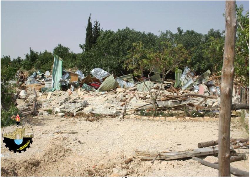
As it has been discussed above, the Jordan Valley has been a target of numerous house demolitions during the last couple of years. Similarly to this case, the surrounding areas of Bethlehem have been threatened extensively by the devastation of Palestinian buildings and houses. In this regard, on May 3, 2012 Israeli occupation bulldozers stormed Al-Makhrour area, west of Beit Jala city and started without prior notification to demolish a 300 square meter restaurant, owned by the local resident Ramzi Nakhleh Qesiyeh from Beit Jala city. Originally kept for future generations there will be soon no space left for Al-M arkhrour to expand and grow. According to the village boundary of 1947, Beit Jala covers an area of 14700 dunums. Today Beit Jala counts only 5000 dunums. In a local EU statement on demolitions from April 13th in 2013, it was stated, that “since the year 2008 more than 2400 Palestinian houses and structures have been demolished in Area C and East Jerusalem, displacing more than 4400 people.”
Image 1: Demolished Restaurant in Beit Jala
To continue, an overview of the latest housing demolitions, which have been executed only at the beginning of 2013, is listed below:
Under the pretext of security, on March 12, 2013 the Israeli civil Administration handed one of Beit Jala’s residents Simone Al- Araj a demolition order for his 6 story building west of Beit Jala.
April 30, 2013: The Israeli High Court of Justice approves another postponement to dismantle Amona outpost. The postponement come to the one set for April 30, 2013 to July 15, 2013. The outpost was established in 1995, and was developed gradually with the addition of structures on Private Palestinian lands.
On May 10, 2013: Demolition of 11 Commercial structures in East Barta’a east of Jenin city and notifying 8 Palestinian families with demolition orders issued under the pretext of building without license.
On May 6, 2013: Israeli Demolition Orders targeting 11 Palestinian Houses in Deir Nidham village West of Ramallah Governorate.
Changing the OPT with Bypass Roads
Today Israeli-only roads across the West Bank have become a defining feature of the apartheid policies implemented by Israel in the Palestinian territories. In addition to violating Palestinians freedom of movement and access, with serious repercussions for health, education and livelihoods, the apartheid roads have consolidated and strengthened the presence of Israeli colonies across the West Bank, ensuring superior access for settlers at the expense of the indigenous Palestinians. From this standpoint, the following section will give an update on the latest developments of road construction in the West Bank.
Road 50 Beit Safafa Bypass
The Israeli 'Moriah Jerusalem Development Company' along with the Israeli Municipality of Jerusalem and the Israeli Ministry of Transportation are currently working to extend the length of Menachem Begin Road (as known to the Israelis) to penetrate deep inside the 1967 borders, on lands of Beit Safafa and Sharafat south of Jerusalem city under the name 'Road No. 50'. The road, as planned, will cause the destruction and confiscation of 234 dunums of lands of the aforementioned Palestinian communities and will complete the Israeli road network in the southern part of the city of Jerusalem.
At the time the Israeli Municipality of Jerusalem is creating a geographical contiguity between Israeli settlements inside the 1948 lands and those inside the occupied State of Palestine through the construction of the Israeli bypass Road No. 50, it will create a bitter and irreversible reality that will affect the Palestinian population of Beit Safafa and Sharafat as the under-construction road will separate between Beit Safaf a and Sharaf at communities; not forgetting to mention that both communities were on a permanent geographical connection over the past years and both depend on each other in all the services. The new Israeli Bypass road No. 50 also passes near the homes of the Palestinians and will deprive them, upon its completion, access to many vital places in the two communities, which were previously accessible to them without having to take alternative routes. Upon road completion also Palestinians of the two communities will be forced to take alternative routes through bridges that will be set up as part of the plan of the road to get to their destinations.
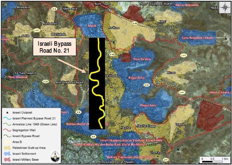
Road 21 Beit Hanina – Shu´fat Bypass
The route of the Israeli bypass road will first connect with the Israeli bypass road No.9, known to the Israeli as 'Yigal Yadin Boulevard', passing by the settlement of Ramat Shlomo (Reches Shu'f at) from the east, and travels northwards, penetrating through the lands of Shu'fat town and continues along its northern slopes towards Beit Hanina town where it intersects at some point with the newly constructed bypass road No. 20. The road continues northwards, cutting through the lands of Beit Hanina and heads towards its last connection point with Bir Nabala Road (known to the Israeli as Beit Horon Road), where it finally connects with the Atarot Industrial Zone (An Israeli Industrial Zone) (see Map 9).
While Israel is providing easy access and geographical to its own people within the city of Jerusalem, Palestinians will have to use another road. Furthermore Bypass Road No.21 will be implemented on the expanse of Palestinian lands and properties in Beit Hanina and Shu'fat. Thus confiscating and expropriating Palestinian lands dissecting Palestinian communities from each other. Moreover, Israel aims to create a network of contiguous Israeli bypass roads within the city of Jerusalem in order to facilitate the entry and exit of Israeli settlers to and from their settlements.
Map 9: Road 21 Beit Hanina – Shu´fat Bypass
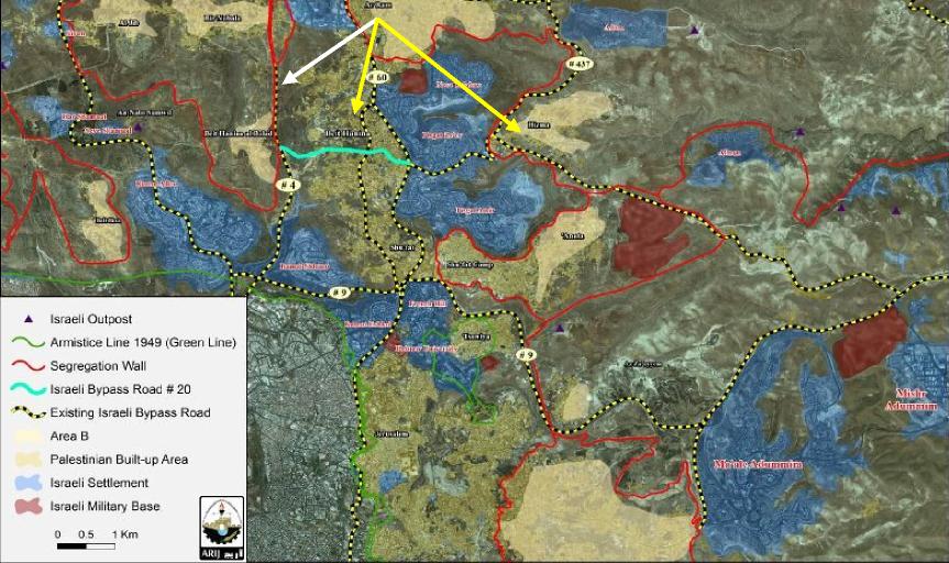
Road 20 Beit Hanina Bypass
Recently, Israel has started to construct bypass Road No. 20 which stretches from east to west along parts of Beit Hanina town, splitting the town's urban center into two more sections rather than those caused by the Segregation wall. The Road emerges from Pisgat Ze'ev settlement intersection and consists of two lanes, one for the Palestinians and the other for the Israelis until it connects with Beit Hanina main road. The road then extends 'as one lane' westward, dissecting through the urban area of the town and connects bypass Road number 443 at some point. The road will extend for 4 kilometers long and will cause the confiscation of 80 dunums of Palestinian land in the town. The goal behind constructing this new road is to connect Israeli settlements located east of Beit Hanina town with those in the west and inside Jerusalem. In addition, a buffer zone will be constructed on one side of the road where a number of Palestinian houses are situated and are now threatened of demolition.
Map 10: Road 20 Beit Hanina Bypass
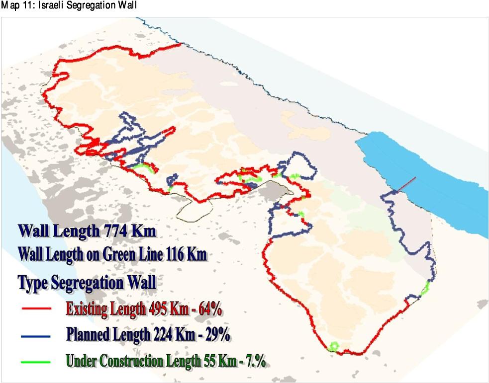
The Status of the Israeli Segregation Wall
In 2002, Israel began construction of the “West Bank Barrier” in order to separate the West Bank from Israel. Currently, the Separation Wall serpentine’s through the West Bank and annexes most illegal settlements rather than running along the 1967 Green Line (Armistice Line). In fact, the Separation Wall is twice as long as the Green Line and 85% of the Wall are located within the West Bank. The barrier, which most Israelis refer to as the “security fence” and most Palestinians as the “apartheid wall”, consists partly of fence (90% of its length) and partly of a concrete wall 6-8 meters high (10%). The Wall includes a “buffer zone” 30-100 meters wide, which often includes electric fences, razor wire, military patrols, cameras and sensors, and trenches. The full route of the Separation Barrier – the portions already built (495 km), those under construction (55 km), and those not yet implemented (224 km)– is approximately 774 km long.
Recent construction orders provide evidence for the progressive proceeding of the Segregation Wall. In consideration of the latter, on December 28th in 2012, Israel issued an extension of validity to military order number 89/06/t (amendment 2) to extend the confiscation of 456 dunums of Palestinian owned lands, until December 31th in 2015, to resume the construction of the Segregation Wall on lands of Beit Surik, Beit Iksa and An Nabi Samuel villages. Furthermore in April, 2013: The Israeli Occupation Authorities started the construction of a section of the Israeli Segregation Wall nearby Az Zaitoun Terminal (HaZeitim Terminal), on lands of Al Ezariyeh town. This wall section is part of the wall that will surround the Ma'ale Adumim settlement bloc east of Jerusalem city.
Since the cabinet’s decision to build the Separation Barrier, Palestinians have filed dozens of petitions against the proposed route. Nonetheless the court mostly rejects these petitions, which is why one could argue that the judgment effectively encourages the State to establish unlawful facts on the ground in accordance with political interests – in the hope that changing such facts at a later point would be deemed disproportionally harmful. Just on April 24th in 2013, the Israeli High Court of Justice has rejected the latest motion submitted by Beit Jala’s residents and land owners along with the Nuns at the Salesian monastery at Cremisan to reroute the Segregation Wall to the suggested new route. On top of the latter fact on May 8th in 2013, the Israeli occupation Army placed an iron gate on the Cremisan – Al Walajeh road which hinders Palestinian access. The agricultural gate is allowed to be used by farmers only. These restrictions on the freedom of movement limit the access of Palestinian villagers to hospitals in nearby towns. Furthermore the educational system suffers because many schools, primarily village schools, depend on teachers who live outside the community and must commute to the school; also family ties and social connections are adversely affected.
Besides the Segregation Wall other physical obstacles such as roadblocks, checkpoints and Barriers obstruct Palestinian movement inside the West Bank. Between 2011 and 2012 there have been removed in total 71. Nevertheless, according to the Roadmap, Israel has to restore the situation to how it was before the 28th of September in 2000. This would indicate the total removal of all checkpoints in the West Bank and Gaza. Today at total of 521 barriers, plus 121 barriers in Hebron can still be found in the West Bank.
What is on the table for final status solution?
It can be concluded that in essence during January 2012 and April 2013 there have been confiscated more than 23,000 dunums of Palestinian lands, uprooted more than 14,000 trees, demolished more than 300 residential structures and more than 900 were threatened of demolition. These facts lead to doubt the seriousness of Israel freezing settlements´ construction and promoting the peace process.
Instead of following the Roadmap it can be observed that Israel is creating facts on the ground, which include the following measures:
-
Leaving Area A& B with no way to expand
-
Israeli Settlements
-
Settlement M aster Plan
-
Settlement Outpost
-
Israeli Closed Military Area Israeli Military Base
-
Segregation Wall
-
Declared State Land
-
Israeli By Pass Roads
-
Settlements Expansion
-
Outpost Expansion
-
Tree uprooting
-
House Demolition & Threats
-
Land Confiscation
Israeli land annexations and settlements expansion are perhaps the single greatest reason the Israeli-Palestinian peace process has failed for 45 years, and they also reflect the heart of the continuing Palestinian condition of occupation, displacement, exile and refugee status.
The Historic Arab Peace Initiative in 2002
The 2002 Arab peace initiative, commonly referred to as the "Abdullah plan" after its chief author, constitutes the most significant and explicit collective Arab declaration in favour of a peaceful, mutually agreed-on resolution of the Arab-Israeli conflict. Arab leaders collectively offered Israel recognition of its right to exist and a normalization of diplomatic ties in exchange for a complete withdrawal from the occupied territories (including East Jerusalem) and a "just settlement" of the Palestinian refugee crisis based on UN Resolution 194. In return the Arab League would consider the Arab-Israeli conflict ended, and enter into a peace agreement with Israel, and provide security for all the states of the region. Nevertheless the international community called on the Israeli government and the Israelis as a whole to accept this initiative to protect the prospects of peace and to spare bloodshed so as to coexist side by side and to provide for the coming generations a secure, stable and prosperous future, Israel has rejected the initiative.
Moreover several Israeli leaders are expressing deep concern about a potential American initiative recognizing 67 borders with comparable and mutual agreed minor swap of the land. In this regard Silvan Shalom, a senior Cabinet minister in Netanyahu's Likud Party, played down the Arab League's decision, saying, "there is nothing new here. Furthermore he stated, “In principle, I
Economic Solution is No Solution
During his recent trip to Ramallah and Tel Aviv, US Secretary of State John Kerry failed to achieve any real breakthroughs in the stagnant negotiations between the Palestinians and the Israelis, despite the satisfaction expressed by the two sides on the round of talks that he had with Palestinian President Mahmoud Abbas and Israeli Prime Minister Benjamin Netanyahu. The US Economic Peace initiative stated that, improving the economic situation will create a favorable atmosphere for political progress while economic recovery will help create an atmosphere of trust between the two parties. However, there is a Palestinian conviction according to which promoting economic support in order to make progress in political talks is a proven failure, because one cannot establish a strong economy under the occupation, while the main issue is primarily about the national liberation of Palestinians living under occupation and the return of those living in exile. It seems very unlikely that Palestinians will accept economic peace as long as their territories are occupied. Therefore what is required is to end the occupation, not to achieve economic development that would prolong it and waive the legal and political rights of the Palestinian people, as any economic development that is acceptable by the Palestinians would be one that resists the occupation and works to end it.
The 4 points Chinese initiative
The four-point Chinese proposal revealed in M ay 2013 by Chinese President Xi Ji npi ng cal ls for the establishment of an independent Palestinian state and peaceful coexistence with Israel, noting that, “to establish an independent state enjoying full sovereignty on the basis of the 1967 borders and with East Jerusalem as its capital is an inalienable right of the Palestinian people and the key to the settlement of the Palestinian question. At the same time, Israel’s right to exist and its leg i ti mate security concerns should be fully respected.”
The proposal also calls for negotiations as the only way to achieve a lasting peace. Importantly, it adds: “The immediate priority is to take credible steps to stop settlement activities, end violence against innocent civilians, lift the blockade of the Gaza Strip and properly handle the issue of Palestinian prisoners, in order to create the necessary conditions for the resumption of peace talks. Comprehensive internal reconciliation on the part of the Palestinians will help restart and advance the Palestinian-Israeli peace talks.”
The third point stresses the centrality of the principles of “land for peace,” relevant U.N. resolutions
and the Arab Peace Initiative, and the fourth point calls on the international community to be engaged by offering guarantees for progress in the negotiations toward a permanent, comprehensive agreement.
The Bottom Line Peace sums up the following:
In order to create sustainable Peace, Palestinians demand from Israel a fair solution which includes the following:
West Bank Land Area = 5661 km²
(Including No Man´s Land area (49 km²) and East Jerusalem) Gaza Strip Area = 362 km²
Total Land Area = 6023 km²
Dead Sea territorial water = 194 km²
Gaza territorial water = 1388 km²
Total territorial water = 1582 km²
These preconditions constitute the Palestinian bottom line on which further agreements could be negotiated in the future. On the other hand Israel has not yet presented a map proposing his borders.
H ow ever according to Oslo it was agreed that “West Bank and Gaza Strip territory, except for issues that will be negotiated in the permanent status negotiations, will come under the jurisdiction of the Palestinian Council in a phased manner, to be completed within 18 MONTHS from the date of the inauguration of the Palestinian Legislative Council…”. In addition, Jerusalem and settlements are
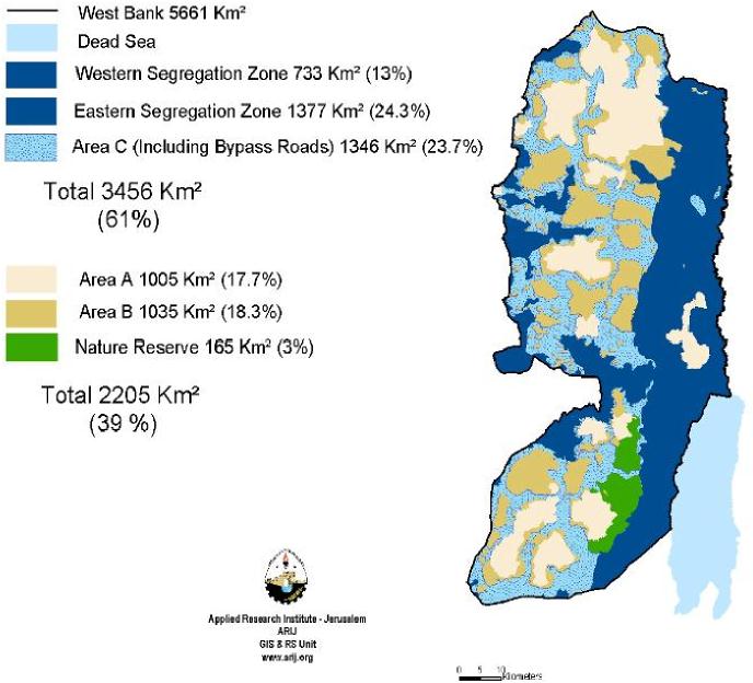
Map 11: Current Status of the West Bank
In the near future it can be expected that Israel seeks to realize the following scenario:
While the Nature Reserve with 3% would stay the same, it is likely to believe that area B would be classified to area A. Furthermore a land transfer from area C to A could gain an additional area of 1137 km². Therefore Israel stays in control of 2319km² (41%) of the West Bank and Palestine of 3342km² (59%).
In conclusion it can be expected that another 20% of the land will be transferred to the Palestinian Authority in the near future. On the long run, Israel states that even a total of 4812km² (80%) are planned to be handed over to the Palestinians. Until then the Palestinians will have to wait and hope for Israels generosity.
Map 12: On the long run Israel’s vision of the Palestinian State on 80% of the West Bank
No Holy Dates ( Final status negotiations should have started in 1996 and finished by May 1999).
Unilateralism replaced negotiations
Weak UN and International Community
Absence of arbitration mechanism.
Palestinians did not feel the dividends of peace despite donor assistance program.
Absence of symmetry between Israelis and Palestinians Changing the TOR of the peace process midway is a bad idea.
Food for thought
Comparing the number of population between Israelis and Palestinian Arabs, it should be noted that notwithstanding the equality of 50% Jews and 50% Arabs, the Palestinians still have less than 12% territorial control. With this in mind it is not surprising that 1.4 million Palestinian Arabs living in Israel, a minority of 20%, only have control over 3% of the Land. Additionally, 700.000 Jews have the control over 40% of Palestinian land in the Occupied Territories.
Based on this status quo, a natural growth of the Palestinian population in the future would become impossible. Considering the agricultural area, the already developed are, the inaccessible area and the protected area, the only available land for future spatial development in the West bank calculates 2,190 km²(39%) from which 1,511km² is designated as Area C.
The maximal available room for natural growth of the Palestinian population can be found in Nabulus (8,6%), Jericho (12,1%), Ramallah (15%), Bethlehem (18%) and Hebron (12%). Together with Qalqila, Salfit, Jenin, Tulkaren, Tubas and Jerusalem, the average space available is less than 10%. This percentage applies approximately for the next 3 years. By the time there will be no space left for Palestinian population to expand and growth. This scenario leads to the question, where the descendants of a whole nation will go when there is no more land available?
In terms of ecological parameters in the West Bank, the suitable land for future spatial development calculates 452 km² (8% of the West Bank; 21% of the Available Area).