
On occasion of World Day to Combat Desertification, 2013:
A large amount of West Bank lands are under ongoing degradation and should be tackled urgently
Help us spread message that land degradation and drought must be central
The World Day to Combat Desertification is a United Nations observes each June 17. This Day has been observed since 1994 by the United Nations General Assembly to promote public awareness relating to international cooperation to combat desertification and the effects of drought, especially in those countries experiencing serious drought and/or desertification. Each annual celebration has a different theme.
This year, the day’s slogan is
“Drought and Water Scarcity” (Don’t Let Our Future Dry Up).
In this occasion the Applied Research Institute Jerusalem (ARIJ) highlights the main figures and facts about drought and land degradation in the occupied Palestinian territory (oPt):
Drought in Palestine:
oPt will become drier through years
Yes we can combat desertification, restore land & prepare for drought.
Drought in the last few years has been a marked increase in a number of droughts in the oPt. The Aridity Index map for the period (200-2010) (map 1) shows that Palestine is located in both arid and semi-arid zones. 26.1% (1574 km2) of the oPt is arid zone and 73.9% (4449 km2) is Semi-arid zone.
In the West Bank, the southern and eastern parts are the most affected by aridity, and the agro-ecological zones of the West Bank ranges from extremely arid in the Jordan Valley and the Eastern Slopes to semi-arid in the Central Highlands and Semi-coastal zones.
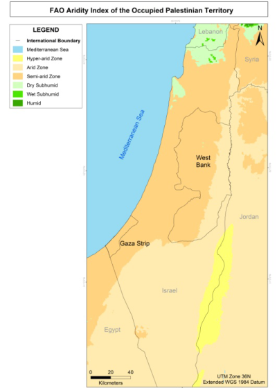
Map 1: Aridity Index in Palestine
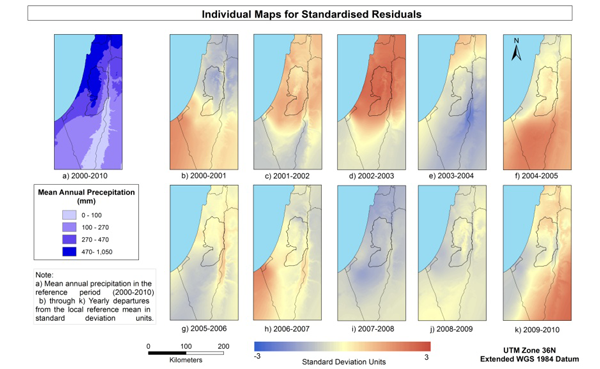
The drought condition in the Opt occurs as a result of the low amount and poor distribution of rainfall, which have drastically affected the growing season of crops and grazing plants during the last few years. This was clear for the period (2000-2010) which shows 7 driest years (2000-2001, 2003-2004, 2005-2006, 2006-2007, 2007-2008, 2008-2009 and 2009-2010) and only 3 wettest years (2001-2002, 2002-2003 and 2004-2005) (map 2). The individuals’ maps represented in map 2 of the standardized residuals show how much each location in Historic Palestine departs from its own mean during the period (2000-2010) in any given hydrological year. The maps show that the whole area contains extreme deviation for the individuals’ locations and many locations received much more or much less precipitation than their respective average.
Drought in Palestine is equally affecting farmers who can not water their crops, and the herders who cannot rely anymore on pastures (which are dry and with very limited grazing capacity as a result of drought) for grazing. Map 3 shows that about 42.7% (2,405 km2) of the West Bank area shows a decrease rate of vegetation in dry areas, especially in the southern parts.
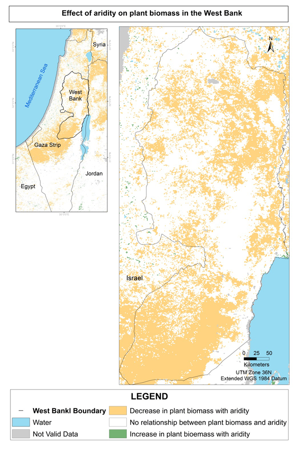
Map 3: Effect of inter-annual of aridity on vegetation (2000-2020)
Land Degradation in the occupied Palestinian territory
When soil is healthy, it holds more water and the effects of drought are less severe
Land Degradation in turn lowers water tables, resulting in water shortages and salt intrusion in coastal areas, and worsening the effects of drought on affected populations and ecosystems. It is predicted that the effects of desertification, land degradation and drought may expose almost two‐thirds of the world’s population to increased water stress by 2025
In Palestine, the amount of land under active degradation processes for the period (2000-2010) was 16% of the West Bank area (876 km2). The results show that the Jordan Valley and the Semi-coastal agro-zones are the most effect by land degradation. 23.7 % of the Semi-coastal zone area (112.3 km2) and 22.3% of the Jordan Valley area (89.4 km2) are under active degradation.