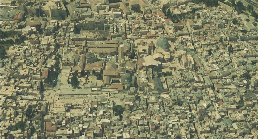
The Applied Research Institute – Jerusalem (ARIJ) and its partners in the project launched the first 3D visualization system for the city of Jerusalem in an easy-to-use site, users can fly over and view landmarks, buildings and streets of the city of Jerusalem in 3D, with the support and funding from the European Commission East Jerusalem Program. ARIJ and its partners, CESVI Fondazione Onlus, The Union of the Charitable Societies-Jerusalem(UCS), and Hasso-Plattner-Institut für Digital Engineering (HPI) in Germany, as part of the project entitled ” Towards Social Inclusion in Community Development by Providing Platforms for Planning and Advocacy “.
It should be noted that during the coming months, the site will be updated to include many of the project outputs, including, for example, A 3D data model and geospatial monitoring system of: (a) geopolitical conditions in EJ; (b) gender disaggregated demographic and socioeconomic indicators; and (c) the quality and accessibility to educational, environmental, recreational (tourism) and health services. Moreover, a 3D visualization system of Palestinian communities in East Jerusalem (EJ) linked to the Geospatial database. Also, a Tourism Information System (TIS) for EJ. Finally, EJ community profiles assessing communities’ needs and developmental priorities in addition to a set of relevant and important research on the sectors of education, health, and the environmental situation in East Jerusalem
To view the site, it can be accessed through the following link: http://alquds.info/
3D visualization http://alquds.info/3d_alquds